INDOEX: A Resilient & Streamlined Implementation Plan for the United States
March 19,1997
A. Clarke, J.A. Coakley, Jr., J. Kuettner, J. Prospero, V. Ramanathan, A. Tuck, and F.P.J.
Valero
Resilient: Capable of withstanding shock without permanent deformation
Streamlined: Contoured to reduce resistance to motion
Preamble: INDOEX, as described in the US proposal, has three interrelated objectives dealing
with aerosol climate forcing including the anthropogenic effects) solar absorption and ITCZ
transport of trace species. The proposal was submitted to NSF, DOE and NASA for a total amount
of $ 6.8M, for 2 aircraft ( NCAR WB-57 or NASA/ER-2, NCAR/C-130 ), 1 surface stations
(Male), participation in ship cruises, modeling and data analyses and integration. The total cost of
the program (including European and Indian components) is about $ 18 M, which includes 3 island
stations (Mauritius, Reunion and Male), 4 aircraft (NOAA-P3 and Dutch Citation-II, in addition to
the above 2 aircraft), 2 ships (German Die Sonne, and Indian Sagar Kanya) and new satellite
aerosol and radiation experiments including TRMM, POLDER and EOS-AM.
Uncertainties in the federal budget over the 3 year life time of the project, complexities in multi-
agency cost sharing and problems with high altitude aircraft have persuaded us to develop an
implementation plan that is relatively resilient to budgetary shocks and reduces the risk of losing
the impressive momentum behind this project.
Implementation Plan: The streamlined execution plan outlined below (and elaborated further
in the attached document) has two components: I) Aerosol Component and II) The full INDOEX
program, which includes the Component I. The attached budget sheet separates the total $ 6.8M
budget under these two components.
(1) Aerosol Component: The salient features of this component are listed below:
*It can be done at about $ 4.5 to $5 M, or roughly 70% of the cost of the full program.
This cost includes field operations, but does not include the following:
a) deployment costs for C-130, the integrated Sounding System from NCAR and drop
sondes from NCAR. We have assumed that NSF will pay for these items.
b) About $2M for the participation of 6 C4 PIs (at SIO, NCAR, Maryland and OSU),
1 site scientist for Male, 3 post-docs, 4 grad students, 4 undergrad students and 1 programmer for
data integration. These will be paid by C4 from base funding to C4 from NSF.
*It does not require ER-2 or WB-57 or NOAA P-3.
*It requires NCAR C-130 and Dutch Citation-II (already approved by the Dutch Govt.).
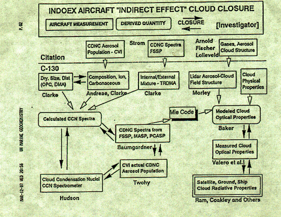
We are requesting 120 hours instead of the original 100 hours. See closure diagrams shown in
Figs 1 and 2 of how the aircraft data will be combined with other correlative data to obtain the
direct and indirect aerosol forcing.
*All other surface and satellite platforms are as mentioned in the US proposal.
*It has a focused new program on the indirect effects, which includes 3 new PIs, new
CCN spectrometer (J. Hudson) and CVI (C. Twohey) measurements of the in-cloud aerosol and
radiation properties, modeling of cloud-aerosol interactions ( M. Baker) and a three-fold increase in
flight hours dedicated to cloud sampling (15 hours in the original proposal to 40 hours in the
current plan ). The following new developments encouraged us to take a more aggressive approach
on the indirect effect:
I) A joint French/US study by S. Bony and W. Collins (sponsored by C4) developed a
new technique to identify low clouds that are not obscured by high clouds from INSAT Vis/IR
data. The study which uses 4 years of winter time INSAT data, reveals a preponderance (30 to
40% of the time) of low-level clouds within 3 hours of flight from Male island. The surface based
Hahn et al reveal even larger frequencies of low-level clouds for this region. Thus, with the C-130
(flight range of 3000 nm) and the Citation (flight range of 1300 nm) we have an excellent
opportunities for sampling polluted low clouds using the closure approach outlined in the attached
diagram.
II) The delay of INDOEX by 1 year, will enable us to access high resolution aerosol and
cloud data that will be generated by CERES, MODIS (EOS-AM) and POLDER (ADEOS). These
will be in addition to our in-house efforts (Coakley, Collins, Desbois and Bony) at retrieving
aerosol and cloud effective drop size from AVHRR. Thus we are quite optimistic of combining in-
situ data with satellite data to gain some understanding of the aerosol forcing effects on larger
regional scales of relevance to climate studies.
The aerosol component has been described in the US proposal under Objective 1. Its
implementation in the present context is described further in the attached section.
II. The full INDOEX program: The salient features of the implementation plan for the full program
are listed below.
*The aerosol component described above
*An add-on of $ 2.2 M in hard funds, deployment costs for WB-57 and P-3 (NOAA has
agreed to pay for P-3 costs as per Fahey & Tuck) to address the overall science described in the
US proposal including objectives 2 and 3.
*In addition to the platform mentioned above under the Aerosol Component, it requires
a high altitude aircraft ( WB-57 or ER-2) and NOAA-P3.
*The following scientific results (in addition to those mentioned under component-I) will
be obtained from this new capability: i) New aerosol particle production in the upper troposphere in
the cirrus outflow region; ii) A much better calibration with EOS and TRMM satellite aerosol
optical properties and radiation fluxes, since the satellite radiances includes effects of aerosols
above the 20000 ft (C-130) to 40000 ft (Citation-II) flight range of the component I aircraft; iii) A
complete characterization of the ITCZ chemistry of the low troposphere (through P-3) and the
upper troposphere (e.g. WB-57); iv) An accurate description of the column cloud radiative forcing
at the tropopause; v) A detailed description of ITCZ-cirrus microphysics and optical properties and
their role in modulating the radiative heating of the ocean; vi) With the latent heating obtained from
TRMM and the column cloud forcing obtained by INDOEX, we obtain a first-time estimate of the
diabatic heating for the ITCZ cloud systems.
This program is listed in full in the US proposal.
Additional Aspects of the Implementation Plan:
Calibration: We will be relying on PIs from Europe (for ship, surface and aircraft data)
and India (for data on 3 Indian stations and ship) to gather data that will help fill important gaps.
Comparability and compatibility of the various instruments are critical for this purpose. The key
issue is calibration. We will adopt the following general strategy. An instrument by instrument
description is given separately as part of this plan (available by March 18th).
*Calibration of US radiometric instruments at the new DOE facility in ARM-Oklahoma
site. These include broad and narrow band radiometers including the spectral radiometers used for
aerosol optical depths. The same instruments will be on Male and the ship. The Indian, European
and US instruments will be compared by docking the ship at Male during the field phase and
during 1998 cruise for at least 3 days
*The European and US aerosol and chemistry instruments will be compared by flying the 2
aircraft (C-130 and Citation) over the same air-mass at near real time (subject to safety constraints).
*Sailing the German and Indian ships side by side combined with aircraft overflights and
satellite over passes. In addition, the US instruments will be on both the Indian and German
ships, thus facilitating comparisons.
Open Data Sharing: The success of the above depends on sharing data freely across
institutional and national boundaries. We will have a data sharing policy that is compatible with
US government and WMO policy. This policy is being drafted by S. Williams (UCAR) and A.
Swathe (India) to be sent to the INDOEX International Steering Committee for approval. In effect,
there will be a 1 year period (immediately after gathering the data) during which the instrument PI
has sole access to her/his data. After this 1 year period, the original data will be archived in
CODIAC (UCAR) and the integrated data will be on CIDS with a password, during the second
year, that will enable all INDOEX PIs to access the data. However, conference presentation or
journal publication within this second year period require written permission from the instrument
PI. After the end of the second year, the password will be removed (provided the data are certified
by the science team) and will be placed on WWW through CIDS.
Prioritization: Another tool for handling unanticipated budget surprises is prioritization of
all of the instruments. We have prepared a comprehensive table of all instruments with priorities
ranging from 1 (must have) to 3 (highly desirable).
 I. Aerosol Forcing Component of INDOEX
The primary focus of this component is the characterization of the direct and indirect
radiative forcing by anthropogenic and natural aerosols over the Indian Ocean. It is important to
note that, the term �radiative forcing� denotes not only the optical properties of aerosols (such as
optical depth, single scattering albedo and phase function) but also the changes in radiative fluxes
(in Wm-2) due to aerosols in clear and cloudy skies. The aerosol objective will be obtained through
measurements made from surface-based stations, satellites, and aircraft.
The aerosol forcing, both direct and indirect and due to both natural and anthropogenic
aerosols, will be determined for the Indian ocean during the winter monsoon season. The
measurement of this forcing will be accomplished as follows: Prior to the deployment of the 1999
aircraft campaign, a climatological data base will be developed through a continuous program of
ground-based measurements made at stations in India and various islands in the Indian ocean. In
addition, ship cruises will periodically transect the ocean. Ground-based lidars deployed during
the pre-INDOEX period will serve to characterize the temporal and vertical distributions of
aerosols. Likewise, satellite observations (AVHRR and INSAT imagery, and after the TRMM
launch, VIRS and CERES) will be used to infer the direct effect of aerosols on reflected sunlight.
The satellite observations will be linked to surface and shipboard measurements of aerosol optical
depths and surface radiative fluxes collected during the 1996, 1997, and 1998 pre-INDOEX
cruises and surface station observing periods. AVHRR and VIRS observations will be used to
retrieve cloud droplet effective radii and cloud optical depths for the low-level clouds in the Indian
ocean both north and south of the ITCZ. Links will be sought between the direct effect of the
aerosols, low-level cloud optical depths, and droplet radii. Thus, prior to the aircraft campaign,
surface, ship, and satellite observations will be combined to establish a data base associated with
the direct and indirect forcing for the Indian ocean.
The aircraft campaign is crucial to the accurate characterization of the aerosol forcing.
Flights with the NCAR C-130 and Dutch Citation (model CITATION II) will be used to probe the
vertical structure of the atmosphere and link its composition to the sources of pollution and to the
top of the atmosphere and surface radiative forcing. The NCAR C-130 will be used to obtain
radiation, cloud and aerosol properties (see Table 6a of US proposal, hereafter described as USP).
The Dutch Citation will be used to obtain concentrations of chemical tracers, and to probe cloud
and aerosol properties ( See Table 16a, P. 62 of the USP for list of Citation instruments ). The
aircraft performance are compared in Table 10 (p. 33) of USP and flight hour allocation is shown
in Table 11 (P. 3) of USP. The range, speed and ceiling for Citation-II are respectively 1350nm,
400 knots and 12.5 km and for C-130 these are respectively: 3000 nm, 290 knots and
8 km.
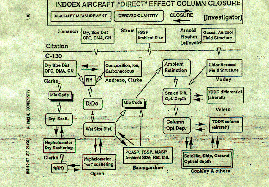
As described in the USP there are three types of aerosol forcing flights (P. 26, P. 34 and
Fig. 19): 1) Radiation-Aerosol Gradient/profiling flights consisting of constant level flight during
the outbound route and top-hat style (Fig. 19c, P. 35) profiling return flight pattern. These flights
will yield horizontal gradient in aerosol forcing and a statistical data base for cloud and aerosol
properties in pristine and polluted air. 2) Aerosol Direct Forcing Closure flight during which the
radiative forcing will be linked with aerosol physics, optical and chemical properties. 3) Aerosol
Indirect Effect Closure flights, during which low-level clouds will be profiled for indirect effects.
The flight hour allocation for the C-130 are as follows:
Gradient/Profiling Flights: 60 Hours
Aerosol Direct Forcing Closure Flights: 20 Hours
Aerosol Indirect Forcing Closure Flights: 40 Hours
The above numbers are approximate estimates. The actual distribution will be decided in the field
by the aircraft scientist ( in consultation with the steering group) based on the success of each
mission.
Missions will be selected and planned based on the analysis of real-time satellite imagery that will
be available at the control center as described in the original INDOEX proposal. The C-130 flights
will begin with an outbound leg, to be flown at about 20 Kft, during which SABL, the lidar on the
C-130, will be used to characterize the vertical structure of the aerosol and cloud layers to be
probed during the flight. The Citation will profile the region up to about 40 Kft for about 500 nm
(from Male) along the flight track of C-130. Since it carries a Mass spectrometer for SO2 (and
other reactive species) and other instruments for CO, CO2, CH4 and NOy and O3 (see Table 16a in
the USP), it will be invaluable for characterizing the source of the airmass influencing aerosol
properties. In addition the DMA, OPC, CVI and FSSP instruments will characterize aerosol
properties from the lower troposphere to about 12 km. These data will be critical (particularly in the
absence of the WB-57) for separating the lower troposphere aerosol effects from mid troposphere
aerosols, while correlating C-130 data with satellite aerosol optical depths. In addition these data
will provide the much needed redundancy in aerosol measurements in the lower troposphere.
To reach the region south of the ITCZ, about 2 of the C-130 flights will require refueling at
Mauritius or Seychelles. For these flights, the Citation will be flown to Seychelles or Mauritius
(ahead of time) to accompany the C-130 and profile the region south of the ITCZ
For the direct radiative forcing, flight legs below, in, and above the various distinct aerosol layers
will be flown. For closure flights within about 500 nm of the base of operations, the Citation and
C-130 will be used to obtain simultaneous sampling of the lower and middle troposphere. These
flights were referred to as closure flights in the INDOEX proposal. The goal is to link the
physical, chemical, and optical properties of the aerosol layers with the radiances measured by the
surface, aircraft, and satellite radiometers.
Likewise, for the indirect radiative forcing, flight legs below the low-level cloud layer, in the
cloud, and above the cloud will be flown. The goal is to link cloud droplet concentrations and
chemical composition to the physical and chemical properties of the subcloud CCN, and in turn, to
link the properties of the CCN to the aerosol plume. Effects due to the mixing of air from above
the cloud layer are to be accounted for through observations of conserved tracers by the Citation II.
The in situ cloud observations are also used to link the cloud optical depths and droplet sizes
derived from satellite and aircraft radiometer data to those actually found in the clouds. At least
two and possibly three conjunctions with satellites carrying either AVHRR or VIRS should arise
during each research flight. The above objectives will be met with the C-130 flying legs that probe
the vertical structure of the atmosphere over time periods of about 2 hrs or less. The vertical
probes will start and finish with the C-130 above the system being probed. Radiometric data
collected by the C-130 before and after the vertical probe will be used to assess the evolution of the
systems during the vertical probe.
The INDOEX Science Team (the authors of the INDOEX proposal) would invite Drs. J.
Hudson, M. Baker and C. Twohy to join the experiment. Dr. Hudson would be recruited to
measure the characteristics of CCN from the C-130 (in addition to the CCN measurements by
Andreae, MPI-Mainz). Dr. Baker would provide expertise in cloud physics for determining the
indirect effect. Dr. Twohy will participate with the CVI on the C-130 (in addition to the CVI
measurements on the Citation by Strom, Stockholm Univ) which will be used to characterize the
properties of cloud droplet nuclei.
Comment on Radiometric Measurements: In view of emerging recent concerns (e.g. the recent San
Antonio DOE-ARM meeting) about broadband, narrowband and multi-band sun-photometer
radiometric measurements, we will employ the following procedures. The new calibration facility
at the DOE-ARM SGP site will be used to calibrate the instruments used in INDOEX. These
include pyrheliometers, diffuse flux pyranometers, sun photometers, shadow band radiometers
and Valero radiometers (these are already at the ARM site and are being compared with other
instruments). In addition, we will contact Dr. Mike King for the use of the new calibration facility
at Goddard. Additionally, we will also use the NOAA-CMDL facilities at Boulder (Ellsworth
Dutton). We will participate at the ARM-shortwave intensive observing period that is coordinated
by Wiscombe. Lastly, all of the radiometers will be calibrated before and after an mission, be it
from a ship, an island or aircraft.
As highlighted in the original proposal, INDOEX offers a first-time opportunity for
measuring the radiative forcing due to aerosols on the continental (the Indian ocean north of the
ITCZ), monthly mean (the winter monsoon season, January-March) scales relevant to the climate
system. While the strategy for obtaining the aerosol forcing outlined above can be undertaken in
any location, INDOEX offers advantages not common to other parts of the globe. INDOEX will
take advantage of the circulation unique to this region during the winter monsoon: Polluted plumes
from the Asian subcontinent blow over a largely cloud-free ocean. The cloud-free oceans not only
facilitate the measurement of the direct radiative forcing, but also, the stability of the atmosphere
in the region during the winter monsoon favors the development of single-layered, low-level clouds,
which can be used to address the indirect forcing. The contrast between the high concentrations of
pollutants near the continent and the low concentrations near the ITCZ, only 1500 km south of the
continent, produces a strong gradient in aerosol concentrations. This gradient is to be used in
INDOEX to determine the radiative forcing. Gradients in pollutants and aerosol optical depths
were observed during the 1995 and 1996 INDOEX cruises. Relatively high concentrations of
sulfates, nitrates, black carbon, and mineral dust aerosols were observed, often in conjunction with
relatively high concentrations of O3, CO and the oxides of nitrogen. In addition, within two
decades, population growth and the consequent increase in energy usage is expected to greatly
increase emission rates in Asia thereby greatly increasing the forcing due to anthropogenic aerosols
over the Indian ocean. As a result, the forcing derived during INDOEX will serve as a benchmark
by which global change could be measured. Furthermore, INDOEX provides a unique
opportunity for scientists from developing countries to work side-by-side with scientists from
developed nations to assess the effects of pollution on global change.
I. Aerosol Forcing Component of INDOEX
The primary focus of this component is the characterization of the direct and indirect
radiative forcing by anthropogenic and natural aerosols over the Indian Ocean. It is important to
note that, the term �radiative forcing� denotes not only the optical properties of aerosols (such as
optical depth, single scattering albedo and phase function) but also the changes in radiative fluxes
(in Wm-2) due to aerosols in clear and cloudy skies. The aerosol objective will be obtained through
measurements made from surface-based stations, satellites, and aircraft.
The aerosol forcing, both direct and indirect and due to both natural and anthropogenic
aerosols, will be determined for the Indian ocean during the winter monsoon season. The
measurement of this forcing will be accomplished as follows: Prior to the deployment of the 1999
aircraft campaign, a climatological data base will be developed through a continuous program of
ground-based measurements made at stations in India and various islands in the Indian ocean. In
addition, ship cruises will periodically transect the ocean. Ground-based lidars deployed during
the pre-INDOEX period will serve to characterize the temporal and vertical distributions of
aerosols. Likewise, satellite observations (AVHRR and INSAT imagery, and after the TRMM
launch, VIRS and CERES) will be used to infer the direct effect of aerosols on reflected sunlight.
The satellite observations will be linked to surface and shipboard measurements of aerosol optical
depths and surface radiative fluxes collected during the 1996, 1997, and 1998 pre-INDOEX
cruises and surface station observing periods. AVHRR and VIRS observations will be used to
retrieve cloud droplet effective radii and cloud optical depths for the low-level clouds in the Indian
ocean both north and south of the ITCZ. Links will be sought between the direct effect of the
aerosols, low-level cloud optical depths, and droplet radii. Thus, prior to the aircraft campaign,
surface, ship, and satellite observations will be combined to establish a data base associated with
the direct and indirect forcing for the Indian ocean.
The aircraft campaign is crucial to the accurate characterization of the aerosol forcing.
Flights with the NCAR C-130 and Dutch Citation (model CITATION II) will be used to probe the
vertical structure of the atmosphere and link its composition to the sources of pollution and to the
top of the atmosphere and surface radiative forcing. The NCAR C-130 will be used to obtain
radiation, cloud and aerosol properties (see Table 6a of US proposal, hereafter described as USP).
The Dutch Citation will be used to obtain concentrations of chemical tracers, and to probe cloud
and aerosol properties ( See Table 16a, P. 62 of the USP for list of Citation instruments ). The
aircraft performance are compared in Table 10 (p. 33) of USP and flight hour allocation is shown
in Table 11 (P. 3) of USP. The range, speed and ceiling for Citation-II are respectively 1350nm,
400 knots and 12.5 km and for C-130 these are respectively: 3000 nm, 290 knots and
8 km.
As described in the USP there are three types of aerosol forcing flights (P. 26, P. 34 and
Fig. 19): 1) Radiation-Aerosol Gradient/profiling flights consisting of constant level flight during
the outbound route and top-hat style (Fig. 19c, P. 35) profiling return flight pattern. These flights
will yield horizontal gradient in aerosol forcing and a statistical data base for cloud and aerosol
properties in pristine and polluted air. 2) Aerosol Direct Forcing Closure flight during which the
radiative forcing will be linked with aerosol physics, optical and chemical properties. 3) Aerosol
Indirect Effect Closure flights, during which low-level clouds will be profiled for indirect effects.
The flight hour allocation for the C-130 are as follows:
Gradient/Profiling Flights: 60 Hours
Aerosol Direct Forcing Closure Flights: 20 Hours
Aerosol Indirect Forcing Closure Flights: 40 Hours
The above numbers are approximate estimates. The actual distribution will be decided in the field
by the aircraft scientist ( in consultation with the steering group) based on the success of each
mission.
Missions will be selected and planned based on the analysis of real-time satellite imagery that will
be available at the control center as described in the original INDOEX proposal. The C-130 flights
will begin with an outbound leg, to be flown at about 20 Kft, during which SABL, the lidar on the
C-130, will be used to characterize the vertical structure of the aerosol and cloud layers to be
probed during the flight. The Citation will profile the region up to about 40 Kft for about 500 nm
(from Male) along the flight track of C-130. Since it carries a Mass spectrometer for SO2 (and
other reactive species) and other instruments for CO, CO2, CH4 and NOy and O3 (see Table 16a in
the USP), it will be invaluable for characterizing the source of the airmass influencing aerosol
properties. In addition the DMA, OPC, CVI and FSSP instruments will characterize aerosol
properties from the lower troposphere to about 12 km. These data will be critical (particularly in the
absence of the WB-57) for separating the lower troposphere aerosol effects from mid troposphere
aerosols, while correlating C-130 data with satellite aerosol optical depths. In addition these data
will provide the much needed redundancy in aerosol measurements in the lower troposphere.
To reach the region south of the ITCZ, about 2 of the C-130 flights will require refueling at
Mauritius or Seychelles. For these flights, the Citation will be flown to Seychelles or Mauritius
(ahead of time) to accompany the C-130 and profile the region south of the ITCZ
For the direct radiative forcing, flight legs below, in, and above the various distinct aerosol layers
will be flown. For closure flights within about 500 nm of the base of operations, the Citation and
C-130 will be used to obtain simultaneous sampling of the lower and middle troposphere. These
flights were referred to as closure flights in the INDOEX proposal. The goal is to link the
physical, chemical, and optical properties of the aerosol layers with the radiances measured by the
surface, aircraft, and satellite radiometers.
Likewise, for the indirect radiative forcing, flight legs below the low-level cloud layer, in the
cloud, and above the cloud will be flown. The goal is to link cloud droplet concentrations and
chemical composition to the physical and chemical properties of the subcloud CCN, and in turn, to
link the properties of the CCN to the aerosol plume. Effects due to the mixing of air from above
the cloud layer are to be accounted for through observations of conserved tracers by the Citation II.
The in situ cloud observations are also used to link the cloud optical depths and droplet sizes
derived from satellite and aircraft radiometer data to those actually found in the clouds. At least
two and possibly three conjunctions with satellites carrying either AVHRR or VIRS should arise
during each research flight. The above objectives will be met with the C-130 flying legs that probe
the vertical structure of the atmosphere over time periods of about 2 hrs or less. The vertical
probes will start and finish with the C-130 above the system being probed. Radiometric data
collected by the C-130 before and after the vertical probe will be used to assess the evolution of the
systems during the vertical probe.
The INDOEX Science Team (the authors of the INDOEX proposal) would invite Drs. J.
Hudson, M. Baker and C. Twohy to join the experiment. Dr. Hudson would be recruited to
measure the characteristics of CCN from the C-130 (in addition to the CCN measurements by
Andreae, MPI-Mainz). Dr. Baker would provide expertise in cloud physics for determining the
indirect effect. Dr. Twohy will participate with the CVI on the C-130 (in addition to the CVI
measurements on the Citation by Strom, Stockholm Univ) which will be used to characterize the
properties of cloud droplet nuclei.
Comment on Radiometric Measurements: In view of emerging recent concerns (e.g. the recent San
Antonio DOE-ARM meeting) about broadband, narrowband and multi-band sun-photometer
radiometric measurements, we will employ the following procedures. The new calibration facility
at the DOE-ARM SGP site will be used to calibrate the instruments used in INDOEX. These
include pyrheliometers, diffuse flux pyranometers, sun photometers, shadow band radiometers
and Valero radiometers (these are already at the ARM site and are being compared with other
instruments). In addition, we will contact Dr. Mike King for the use of the new calibration facility
at Goddard. Additionally, we will also use the NOAA-CMDL facilities at Boulder (Ellsworth
Dutton). We will participate at the ARM-shortwave intensive observing period that is coordinated
by Wiscombe. Lastly, all of the radiometers will be calibrated before and after an mission, be it
from a ship, an island or aircraft.
As highlighted in the original proposal, INDOEX offers a first-time opportunity for
measuring the radiative forcing due to aerosols on the continental (the Indian ocean north of the
ITCZ), monthly mean (the winter monsoon season, January-March) scales relevant to the climate
system. While the strategy for obtaining the aerosol forcing outlined above can be undertaken in
any location, INDOEX offers advantages not common to other parts of the globe. INDOEX will
take advantage of the circulation unique to this region during the winter monsoon: Polluted plumes
from the Asian subcontinent blow over a largely cloud-free ocean. The cloud-free oceans not only
facilitate the measurement of the direct radiative forcing, but also, the stability of the atmosphere
in the region during the winter monsoon favors the development of single-layered, low-level clouds,
which can be used to address the indirect forcing. The contrast between the high concentrations of
pollutants near the continent and the low concentrations near the ITCZ, only 1500 km south of the
continent, produces a strong gradient in aerosol concentrations. This gradient is to be used in
INDOEX to determine the radiative forcing. Gradients in pollutants and aerosol optical depths
were observed during the 1995 and 1996 INDOEX cruises. Relatively high concentrations of
sulfates, nitrates, black carbon, and mineral dust aerosols were observed, often in conjunction with
relatively high concentrations of O3, CO and the oxides of nitrogen. In addition, within two
decades, population growth and the consequent increase in energy usage is expected to greatly
increase emission rates in Asia thereby greatly increasing the forcing due to anthropogenic aerosols
over the Indian ocean. As a result, the forcing derived during INDOEX will serve as a benchmark
by which global change could be measured. Furthermore, INDOEX provides a unique
opportunity for scientists from developing countries to work side-by-side with scientists from
developed nations to assess the effects of pollution on global change.