 |
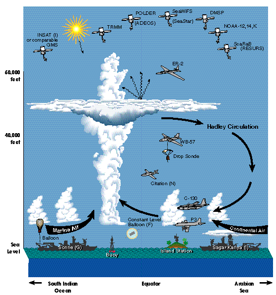
| Figure 12a. INDOEX primary and supporting observing platforms. |
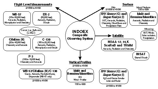 |
| Figure 12b. Schematic of INDOEX composite observing system. |
The fundamental design requirement is to determine from observations:
* Monthly mean regional distribution of aerosol optical depth, the vertical distribution of ozone and water vapor, and the solar radiation fluxes at the tropopause and at the sea surface. The region of interest is 25šS to 20šN.
* Atmospheric and surface radiative forcing by aerosols and clouds, and the influence of pollutants (e.g., SO2, CO, NOx) on the radiative forcing.
* Competing effects of aerosol cooling and the tropospheric ozone IR greenhouse effect from neighboring continents.
* Chemical and physical properties (size distribution, water/ice phase and shape) of the aerosols (whether sulfates, soot, black carbon or dust) and clouds.
* Vertical profiles of gaseous species (including water vapor) from the surface to at least 18 km in the ITCZ as well as north and south of the ITCZ.
The required parameters to meet the primary and supporting objectives of INDOEX fall under the following broad categories:
* Aerosols. The required measurements include size distribution, chemical composition, and radiative properties such as single scattering albedo and optical depth.
* Gaseous Species. SO2, O3, CO and NOx from the surface to tropopause for Objectives 1 and 2, and other reactive species for Objective 3.
* Radiation. The required measurements include broad band and spectral solar and longwave radiation fluxes at the sea surface and at altitudes corresponding to the tropopause, the cirrus anvil top and base, and the top of the boundary layer.
* Water vapor, temperature, and winds. The required measurements include SST and vertical profiles of temperature, winds, and water-vapor concentrations from the sea surface to about 25 km.
* Cirrus microphysical parameters. These include size distribution of ice crystals, particle shape, and cloud-top and cloud-base altitudes.
A detailed listing of the parameters is given in Tables 3a, 3b and Table 4. These tables prescribe the required spatial resolution, absolute and relative accuracies, and specifics of the observational platform for each of the measurements. The specific objective of each measurement is defined in the last column.
The various platforms required to meet INDOEX objectives are shown schematically in Figure 12a and the composite observing system, consisting of primary and supporting platforms is shown in Figure 12b. The measurements fall into four distinct categories:
* Flight-level measurements: Observations of aerosols, gaseous species, water-vapor concentrations, radiation fluxes, optical properties and microphysics are required at specific altitudes. These have to be made from aircraft platforms and, hence, are referred to as flight-level measurements.
* Vertical profiles: Temperature and water-vapor concentrations from the surface to about 25 km in altitude are best obtained from sondes deployed from aircraft or launched from ship and island stations. Some additional profiles will be obtained by aircraft.
* Surface measurements: Observations of SST, surface air aerosol/chemical composition, and radiation fluxes at the sea surface are best obtained from an aircraft within the boundary layer, two ships, a surface site in the open ocean and two island stations (Malé and Reunion).
* Satellite measurements: In order to relate and characterize the measurements from these platforms in terms of synoptic, convective, and cirrus cloud systems, space-borne observations of radiances, aerosol/cloud properties, ozone and water vapor are required.
The fundamental scientific objectives of INDOEX are organized into three focused areas of inquiry: natural and anthropogenic aerosol radiative forcing, excess cloud absorption, and the evolution and transport of trace species in the NE monsoon and the ITCZ.
Primary platforms have been especially designed and commissioned by the INDOEX investigators to meet the primary objectives of the experiment. Supporting platforms include operational systems (e.g., satellites and island stations) and experimental satellites (Scanner for Earth Radiation Budget (ScaRaB) and Tropical Rainfall Measuring Mission, TRMM) commissioned under the auspices of other programs such as NASA-Earth Observing System (EOS).
|
| Figure 12a. INDOEX primary and supporting observing platforms. |
|
| Figure 12b. Schematic of INDOEX composite observing system. |
Aircraft
The most important questions raised in the primary objectives will be investigated via a series of flights collecting data at the following altitudes:
a. Upper-level aircraft, the NASA ER-2: This aircraft will be used for radiation fluxes and water-vapor/ozone concentrations above the cirrus tops; intercalibration of tropopause radiation fluxes and satellite observations; radiative impact of stratospheric aerosol layer; remote sensing of the vertical structure of the aerosol and cloud layers being observed by other platforms.
b. High to mid-level aircraft, the NCAR WB-57: All 3 objectives require
this aircraft:
1) Profiling flights: profile the aerosol/cloud
micro-physics, radiation and chemistry of the free tropospheric layer
up to and including the altitude of the high-altitude aircraft; in
addition, determine cloud-base and cloud-top altitudes as well as
ice-crystal size and shape, from the -30šC level to the maximum
altitude the WB-57 can achieve;
2) Collocated constant level
gradient flights: during these flights, this aircraft will fly below
cirrus base at a constant level, but simultaneously with the ER-2
flying above the tropopause. These collocated flights are required to
obtain the solar absorption due to cirrus clouds and upper tropospheric
aerosols; and to obtain the latitudinal gradients in radiation fluxes,
aerosols and gaseous species across the ITCZ; and
3) Dropsondes
deployed from the WB-57 will measure vertical profiles of temperature
and horizontal winds, as well as water-vapor concentration between the
cirrus base and the sea surface.
c. Mid-level chemical profiling aircraft (Dutch Citation): This aircraft, funded by the Dutch government to Prof. J. Lelieveld, will be used to profile the gaseous species in the mid to upper troposphere to understand the convection-ozone chemistry issues.
d. Mid to low-level aircraft, the NCAR C-130, for the aerosol and cloud-radiation objectives: The primary objective of the C-130 is to probe the aerosol composition, optical and chemical properties of boundary layer and the lower troposphere aerosols; estimate the direct and indirect radiative forcing effects of aerosols; estimate the solar fluxes at the sea surface; and estimate the solar absorption by low level clouds. For the last task, the C-130 flights have to be collocated as close as possible to the WB-57.
e. Mid to low-level aircraft, the NOAA P-3, for the ITCZ chemistry objectives.
Ship
In situ measurements (north-south gradients across the ITCZ) of SST, sea-surface solar insolation, aerosol and gaseous species concentrations, cloud base altitudes and precipitation will be made from two research vessels: a German research vessel (R/V) Sonne, requested by Drs. Kley and Crutzen from the German government; and an Indian vessel, R/V Sagar Kanya, requested by Dr. A. P. Mitra from the Indian government. Upsondes launched from the ship will measure vertical profiles of temperature, winds, water vapor, and ozone concentration from the surface to about 25 km. The Sonne and the Sagar Kanya will be funded by the German and the Indian government respectively. Participation by the US scientists in these vessels has to be funded by the US government and funds for this purpose have been included in this proposal. However, if the German government does not grant permission for R/V Sonne, we will request a National Science Foundation (NSF) operated and funded research vessel.
Surface Stations
Surface observations of aerosol optical depth, radiation fluxes, water vapor and ozone soundings from Malé (4.2°N, 73.5°E) and Reunion (21.06°S, 55.36°E)/Mauritius (20.17°S, 57.33°E) are needed continuously during the field phase to monitor the continental (Malé) and pristine southern hemisphere (Reunion/Mauritius) marine air. High quality optical and chemical observations are being made by the French scientists at Reunion. Since the site at Reunion is at an elevation of 3000 m, additional pyranometric radiation observations will be made by the Center for Clouds, Chemistry and Climate (C4) from Mauritius. These surface observations, in conjunction with simultaneous aircraft data (collected during overflights) are also critical for linking in situ aerosol properties to their radiative impact.
The aircraft and ships, by themselves, cannot provide the desired regional scale, time-averaged estimates. For example, the measurements made by the high-altitude aircraft along a path will be insufficient to estimate the heating rates of a cloud system, such as a cloud cluster. We will use satellite measurements to gain the synoptic perspective and aircraft measurements for in situ truth. Several supporting platforms will be needed; these include:
* Polar and geostationary satellites for solar and infrared radiation cloud properties, column water vapor, and their diurnal variations.
* Surface sites for SST, solar radiation, precipitation, and boundary-layer humidity and wind observations.
* 2 island stations (Malé and Reunion/Mauritius) for continuous sampling of temperature and humidity soundings, vertical velocities, radiation and aerosol measurements.
INDOEX will use the following observations:
* Indian Geostationary Meteorological Satellite (INSAT) data for 1985 to 1990 (available at NCAR) for assessing diurnal, synoptic and intra-seasonal to inter-annual variations in cloudiness and the ITCZ; INSAT and other geosynchronous satellites data for the period 1996 to 1999.
* Pre-INDOEX cruise data collected onboard NOAA and Indian ships from 1995 onwards.
* Surface aerosol and ozone data collected from 6 surface stations in India to understand the daily and monthly variations in aerosol concentrations, both before and during the field phase.
The absolute accuracy of measurements is very critical for achieving the INDOEX objectives. A very effective procedure for assessing the absolute accuracy of the measured quantities is relative to measurements taken from independent instruments within one platform and from identical or independent instruments from different platforms. Intercomparison flights should be made at the beginning, middle, and end of the observing period. The intercomparison flights should include all the aircraft, the research vessels, and the INSAT data collection periods. Whenever possible, such flights should also overfly the surface sites and be collocated with the overpasses of one of the NOAA polar orbiters and TRMM.